New photography map reveals ‘a century of England from the air’
Historic England has created a useful tool for planning, heritage projects and archaeological investigation, featuring 400,000 aerial photographs dating back to 1919 & covering nearly a third of the country
What to read next

Government launches new biodiversity net gain consultation
Latest proposals are designed to ensure developments are ‘nature positive’, with biodiversity gain ‘at the heart of all decision-making and design’

Investors back ‘game-changing’ AI platform for property developers, designers & planners
Norwegian start-up Spacemaker raises $25m in Series A funding from Round Hill Ventures, Atomico, Northzone & Nordic developers NREP and OBOS
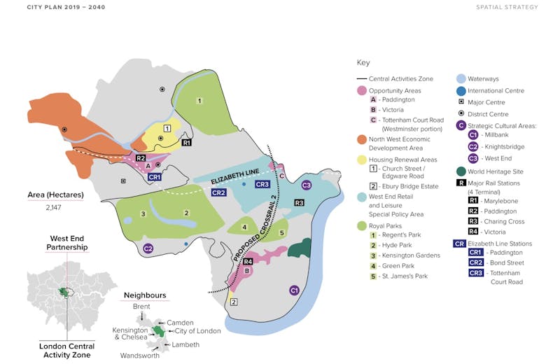
‘A clear framework for developers in one of London’s most spatially constrained boroughs’: Key policy headlines from the draft Westminster City Plan
Savills summarises the main takeaways from the borough’s planning and development blueprint for the next two decades, which has just been found sound by the planning inspectorate.
Most read

Savills consolidates flagship PCL teams
Big-brand agency is relocating its Knightsbridge operations to Sloane Street.

Full-floor shell penthouses atop Park Lane ‘Grande Dame’ building seek £50mn
Agents instructed on 19,000 sq ft with planning for four big laterals in Art Deco landmark overlooking Hyde Park.

High-profile buying agency toasts 20 years in business
Sloane Square-based firm reveals acquisition record and says industry shifts have made the market 'increasingly difficult' for buyers to navigate.

Super-prime construction firm builds leadership team
Knowles makes trio of senior appointments amid ‘increasing demand’ for top-end services in London and further afield.

What do the wealthiest want? Four questions, 32 experts, ten key findings
'Something has shifted at the very top of the market,' declares LPF boss Priya Rawal after consulting a panel of luxury property insiders.

High-profile developer wins £1.9mn SDLT battle over Chelsea mega-mansion
Upper Tribunal dismisses HMRC appeal in long-running tax dispute.

Developer offers £42k private school sweetener to homebuyers
Two years of fees are on the table at a north London scheme as firms look to tempt purchasers with increasingly inventive incentives.

‘2026 likely to prove one of the lowest years for London transaction volumes on record,’ warns Foxtons boss
Major estate agency's profits hit hard by 'materially lower' sales volumes and 'short-term volatility' in the lettings market.

‘A once-in-a-lifetime opportunity’: Historic Cotswolds estate hits the open market
Grade II* mansion in 230 acres, used as a school for more than a century, has the potential to be reborn as a spectacular private residence.

Knightsbridge Gate nears sell-out after £30mn double deal
Middle Eastern buyer picks up two neighbouring apartments at the luxury PCL scheme, leaving just one residence available.
LATEST ARTICLES

Rare receivership sale completed on Eaton Square
Lateral Belgravia penthouse sells above guide after drawing ‘very high’ viewing numbers.

In Conversation: William Bles on the changing HNW client & the new rules of super-prime design
HBA Residential's new EMEA Principal discusses the dramatic shift in expectations among global buyers over the last decade - and what it means for luxury designers and developers.

Latest UK transaction figures suggest ‘increase in underlying property market activity’
Industry Reactions: Property insiders weigh in as sales volumes edge higher.

Rightmove revenue climbs as agent retention hits decade-high
Plc's profits rise as estate agents continue to spend more with the property portal.

Required Reading: What the Royal Lodge saga tells us about subletting
Andrew Mountbatten-Windsor's recent example highlights how crucial it is to get the rules in writing, explains Kate Stockdale.